By Terry Sovil from the February 2017 Edition
An earthquake, also called a temblor, is the shaking or rolling of the earth’s surface. It is when two “plates” suddenly slip and slide past each other or break apart due to tension or pressure. You may feel it as a rumble or shock under your feet or it may be so powerful it can flatten buildings or large sections of a city. They occur on land or at sea.
Terms
There may be smaller shocks before (foreshock) and some after (aftershock) from the main earthquake (mainshock). Foreshocks can be so big you may feel it was the mainshock. Foreshocks and aftershocks can occur within days, weeks or months of the main earthquake.
In the diagram below, you can see the inner core, the outer core (liquid in nature), the mantle (semi-molten rock called magma) and the crust. The crust is the hard part of the earth that forms the surface. It includes the land masses we live on, the oceans and the ocean’s depths. Earthquakes form in the outer crust.

The crust thickness varies from 5 to 40 km (3 to 25 miles). The mantle is about 2,900 km (1800 miles) thick. It makes up 82% of the earth’s volume and 68% of its mass. The outer core temperature is very high and is liquid. The molten iron here is thought to be the source of the earth’s magnetic field.
Temperatures range from 3,200 C to 4,000 C (5,400 to 7,200 F). The inner core is very hot and keeps the inner core solid (4,000 to 4,500 C or 7,200 to 8,100 F).
Plates, Faults, Richter Scale Tectonic Plates Huge layers of the earth’s upper crust. They move, slide, stretch and collide with other layers. Each plate is 50-250 miles (80-400 km) thick!
Faults Also called fault plane or fault lines. Weak lines that develop in plates, usually on the surface of the earth. If a fault line slips, an earthquake may result. The hypocenter is the location directly below the earth’s surface where the earthquake starts. The epicenter is directly above it on the surface of the earth.
Seismograph / The Richter Scale A seismograph measures the magnitude of an earthquake. The Richter scale (RS) is a measure to compare earthquakes. It is calculated in levels of ten. So a measure of 4 is ten times more than a measure of 3. An earthquake of 3-5 is considered minor, 5-7 is moderate and 7-8 is major, and 8 or more is great and devastating.
How do they happen?
Imagine what happens when two plates collide using the diagram above. The earthquake develops in the 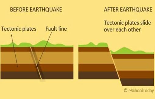 crust of the earth.
Think of the plates as similar to a jigsaw puzzle. As they push against each other with great pressure, it finally “gives” along that fault line and there is an earthquake. Much like ripples on a pond when you throw a rock, the plates direct tremendous energy outward. The earth will shake and roll, causing damage.
Types of Earthquakes
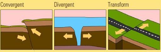
There are three main forms of earthquakes, depending on the plate movements. It could occur in a convergent, where one plate is pushed over another creating a thrust fault. It could be a divergent boundary where the plates are forced apart, forming a Rift Zone, or new floor. This is common on ocean floors, with the Mid Atlantic Ridge being an example. Last it could be a transform fault. Unlike the other two the plates here slip by each other. This is also called a strike-slip. See the diagram be-low.
Tsunami
A tsunami, massive ocean wave, can be triggered by an earth-quake that occurred in the sea. This happens when the plates move, or focus, so that one slips under another. Tsunamis may also be caused by underwater landslides or the eruption of a volcano. The waves created can grow to a size of 100 feet or 30 meters. Out at sea, the waves travels very fast and is only 1-2’ / .5M in height. It will pass under a boat with no problems. It is not like a conventional wave as it runs from the surface to the bottom of the ocean. As it travels it gains speed, up to 500 mph / 804.672 kph. When it reaches shore, and the depth of the water decreases, the wave grows in height.
Manzanillo and Colima
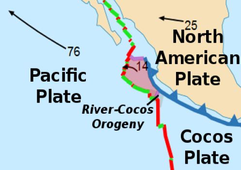
We are surrounded by the North American plate, The Cocos plate and the Pacific plate. The Rivera Plate is a small plate, a microplate, located off the south of the Baja. It is believed that the Rivera Plate separated from the Cocos Plate 5-10 million years ago.
This area has caused some of the strongest earthquakes in the history of Mexico:
- June 3, 1932 the largest earthquake in the history of Mexico, RS 8.2, in Jalisco with an aftershock of 7.8.
October 9, 1995 an RS 7.6 earthquake occurred beneath the Jalisco region with significant loss of life and property - An RS 7.8 earthquake on January 24, 2003 occurred near Colima city resulting in 29 dead, 300 injured, 10,000 left homeless, 2005 homes destroyed and 6,615 homes dam-aged. The quake was felt in Mexico City, most of Mexico and into Southern Texas. Landslides closed Colima-Guadalajara highway and the port of Manzanillo. A local tsunami of about 1m / 3 feet was recorded in Manzanillo.
Download the full edition or view it online
—
Terry is a founding partner and scuba instructor for Aquatic Sports and Adventures (Deportes y Aventuras Acuáticas) in Manzanillo. A PADI (Professional Association of Dive Instructors) Master Instructor in his 36th year as a PADI Professional. He also holds 15 Specialty Instructor Course ratings. Terry held a US Coast Guard 50-Ton Masters (Captain’s) License. In his past corporate life, he worked in computers from 1973 to 2005 from a computer operator to a project manager for companies including GE Capital Fleet Services and Target. From 2005 to 2008, he developed and oversaw delivery of training to Target’s Loss Prevention (Asset Protection) employees on the West Coast, USA. He led a network of 80+ instructors, evaluated training, performed needs assessments and gathered feedback on the delivery of training, conducted training in Crisis Leadership and Non-Violent Crisis Intervention to Target executives. Independently, he has taught hundreds of hours of skills-based training in American Red Cross CPR, First Aid, SCUBA and sailing and managed a staff of Project Managers at LogicBay in the production of multi-media training and web sites in a fast-paced environment of artists, instructional designers, writers and developers, creating a variety of interactive training and support products for Fortune 1000 companies.