By Dan and Lisa Goy from the July 2017 Edition
January 15 and 16, 2016 (Days 9-10)
We leave Veracruz and continue the southward journey along Hwy 180 to Catemaco and the Tepetapan RV 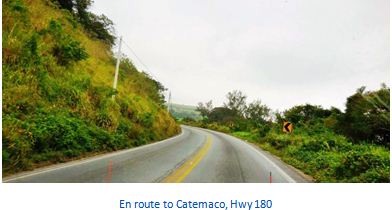 Park. It was Mike and Kelly’s turn to take the lead and they did just fine. This was a very scenic drive, lots to see and not that busy.
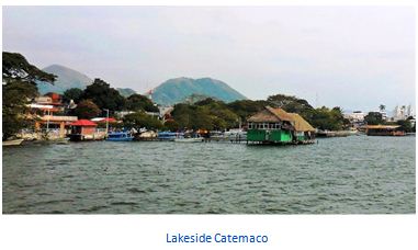
Catemeco is a tourist destination with its main attractions being Lake Catemaco, remnants of the region’s rainforest and a tradition of sorcery/witchcraft that has its roots in the pre Hispanic period and is mostly practiced by men. We arrived at our destination before lunch and settled the RVs into the Tepetapan RV Park. Great campground with many amenities and very reasonably priced at $250 pesos per night.
First order of business was to find a lavandería (laundromat) which we had not done since we entered Mexico. The gals collected everything and the guys headed out to see what we could find. Only a few blocks from Tepetapan we found Juanita’s, 16 pesos per kilo and they would deliver it to the park before we left.
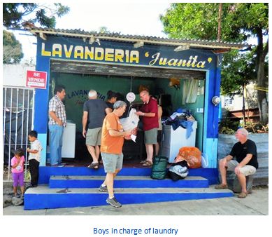 Who could beat that, eh?
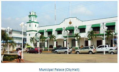
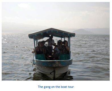
On our second day in Catemaco, we all walked into town to lakeside. The gang went on a boat (lanchas) tour to Monkey Island and took a look around the lake which included monkeys and crocodiles. Monkey Island is named after the non- native red-cheeked changos, monkeys brought here by the University of Veracruz from Thailand and used for study. Lisa and I stayed back and walked up to the very ornate Basilica of Our Lady of Mount Carmel Church which was not completed until the 60s. The Zócalo and Municipal Hall (Municipal Palace) in Catemaco are also worth a stop.
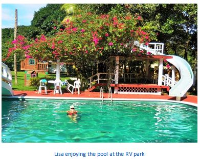
Later we headed back to the RV Park for a siesta and a dip in the pool. The rest of the group returned in the afternoon. From all reports, they had a fun time on the tour and, after arriving back to town, spread out for lunch.
We learned about live entertainment in town tonight but decided to wait for the laundry which arrived at  8:30 pm, vacuum- packed, it seemed, then most walked into town for the re- opening of malecón celebration that included a band and dancers from Mexico City. There were literally thousands of people, shoulder to shoulder and yes, the entertainment was loud. On the way back to the campground, we stopped for a drink at a bar on the lake that included a singer who clearly had been performing for many years. Lots of fun, for sure!
Other Catemaco attractions
 The main plaza is popular with both residents and visitors. The main structure here is the Basilica of Our Lady of Mount Carmel. Veneration of this version of the Virgin Mary, the patroness of the municipality, began in the early colonial period, as a substitute for the local worship of Chalchiuhtlicue, the goddess of water and fishermen.
This basilica contains an image of Our Lady of Mount Carmel, which has been credited with miracles. It is rivaled in devotion only by a shrine on an island in Lake Catemaco called El Tegal, where the Virgin Mary is said to have appeared. The current structure was begun in 1799 but was not finished until 1961.
The church is a combination of Baroque and Neoclassical, with a cupola 21 meters high. The surrounding stained-glass win- dows depict the lives of Jesus and Mary. Each year, Our Lady of Mount Carmel is celebrated at this basilica, with a launching of boats in procession to Agaltepec Island and traditional music including danzón, Son Jarocho and other tropical music, using guitars, violins, the vihuela and double bass.
Other landmarks in the city include the Statue of the Fisherman, the Torre del Reloj (Clock Tower), the 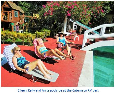 Brizuela Absalón House, the Gasca Blanco House and the Herrera García House. The Casa de los Tesoros is a large gift shop, which offers ba- gels, bizcochos and Mexican handcrafts and folk art. There is a bus station principally connecting the city with the ports of Veracruz and Coatzacoalcos.
Hwy 180 thru this region is a very scenic drive as the municipality is located in the Los Tuxtlas mountain region in the south of Veracruz, a rugged area of recent volcanic origin. It is located in a valley between the San Martín Volcano and the Santa Marta mountain ranges, extending from Lake Catemaco to the Gulf of Mexico shore, with an average altitude of 340 meters above sea level.
Most of the wild vegetation has been destroyed, with 391.6 km2 used as pasture for animals, 50.8 km2 used for agriculture and 39.4 km2 with secondary vegetation. Only 84.8 km2 remains as rainforest and 81.2 km2 is covered by water.
 The remaining natural vegetation is high tropical perennial rainforest, giving way to wetland vegetation and mangroves near and on the Gulf coast. Native tree species include cedar, royal palm, palo de agua, ojite (Brosimum alicastrum), ojueta, marayo and rabo lagarto (Equisetum arvense). The Nanciyaga Ecological Reserve preserve most of what is left of the rainforest that en- veloped Lake Catemaco. Wildlife include small mammals such as squirrels, armadillos, rabbits, weasels and raccoons. Many bird species inhabit the lake area including herons, owls, cardi- nals and more. Numbers are highest in December with the arrival of migratory species. Spider monkeys were extinct but have been reintroduced in the Lake Catemaco area.
For most of the year, the climate is warm and humid. The average temperature ranges from 20 to 26C, with the coolest months from November to January and the warmest in the summer. Our visit in January was warm enough for us.
It rains all year because of warm humid winds from the Gulf of Mexico, but annual totals vary from 1900 mm 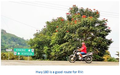 to 4600 mm. The quantity of rainfall also varies by season, with a relatively dry season from March to June, when totals are half that of the rest of the year.
Winds are predominantly from the north. From February to October, most winds are from the northeast, which are warmer. From November to January, cooler winds from the north dominate due to cold fronts from the north called “nortes.”
The lake and its twelve islands have been designated as a federal, natural park. The largest of these islands is Agaltepec, 750 meters long and 150 at its widest, covering 8.5 hectares. This name is from Pipil and Nahuatl and means “stone canoe” or “canoe hill.” It is also called Crocodile or Dragon Island in reference to its shape which resembles the animal when seen from certain perspectives.
 Its vegetation remains intact with over 1,600 trees of 63 species. In 1988 and 1989, two groups of howler monkeys, which are in danger of extinction, were brought to the Agaltepec Island as an attempt to preserve the species. Since then the animals have multiplied to over 100 and their cries can be heard in the nearby city.
The island is federal property and is maintained by the Universidad Veracruzana. There is also an archeological site on the island. Tanaxpillo, better known as the “Island of the Monkeys.” This name and fame come from a colony of stump-tailed macaques that live there, introduced as part of a research project in the 1970s. They are maintained by the university although they are also fed by local boat operators. One other popular island for visitors is the Heron Island (Isla de las Garzas), a sanctuary of the species, which cover the trees and have painted them white from their excrement.
The other major body of water within the municipality is the Sontecomapan Lagoon. It is a large, shallow  estuary, which opens to the sea, covering 900 hectares in a very irregular shape. Its average depth is only two meters with the deepest part at five meters. The lagoon is fed by various rivers and streams with the salinity of the water increasing the closer one is to the Gulf of Mexico.
It is mostly separated from the Gulf by the Barra de Sontecomapan, a stretch of beach and offshore reefs. Canals also stretch from the main body of water, and both these canals, and the edges of the lagoon, contain mangroves. The town of Sontecomapan, which the lake is named after, has docks for fishing and tours to see the area’s vegetation, especially its mangroves.
Lake Nixtamalpan is located in a crater filled from underground. Its depth is unknown, but is estimated at fifty meters, and covers and area of about twenty hectares.
The municipality has a coastline on the Gulf of Mexico. The most visited beaches here are Peña Hermosa in Tatahuicapan de Juárez, La Perla del Golfo in Mecayapan and Playa Escondida, most popular with foreign tourists.
The most important commercial activity in the region continues to be tourism, mostly centered in the city of Catemaco. The area attracts mostly Mexican visitors, with the busiest times being traditional vacation periods such as Holy Week, some parts of summer and long weekends.
Most come to see the lake, including boat tours to the various islands, and visit the sorcerers. The area has also attracted the film industry, with films such as Medicine Man with Sean Con- nery and Apocalypto, filmed by Mel Gibson.
Ecological tourism has grown in the municipality, allowing rural communities such as Ejido Lopez Mateos and Ejido Miguel Hidalgo to offer cabins and access to attractions such as rainforest, rivers and waterfalls, like the Cola de Caballo and Poza Reina. There are also archeological sites such as Las Margaritas and a pyramid on El Cerrito just outside of Catemaco city.
The “witches” of Catemaco
 Catemaco is known in Mexico for its community of “brujos,” which can be translated as “witches” or “sorcerers” as most are men. The history of magical practices here extends back to the pre-Hispanic period and may have survived because of its relative isolation, but Lake Catemaco is said to emit a kind of en- ergy, along with the Mono Blanco Mountain that rises above it.
These magical practices are an uneasy mix of Catholic rite, especially the invocation of saints, and pre-Hispanic beliefs and rituals. There are practitioners of both “white” and “black” magic, with the white version being more acceptable. Those who practice the black version charge more.
Sorcery is one of the main attractions of Catemaco. The belief in magical practices has attracted people from all walks of life, from waiters and taxi drivers to national-level politicians. Ve- racruz governor Fidel Herrera Beltrán even pushed for a na- tional school for sorcery in Catemaco, without success and is a regular at the annual event. Visitors usually seek limpias (ritual cleansings), healing or something to give them an edge in business. These magical practices have also migrated out of the Catemaco area as residents move to other places such as Ciu- dad Juárez to work.
Although the sorcery is a main attraction, it is not promoted as part of Halloween or Day of the Dead. The main event for prac- titioners is the annual Congreso Nacional de Brujos de Cate- maco (officially called the Ritos, Ceremonias y Artesanías Mági- cas because of objections from the Catholic Church). The main event is the opening, on the first Friday of March.
This begins with a “black mass” on the edge of Lake Catemaco by the “brujo mayor” (loosely translated as 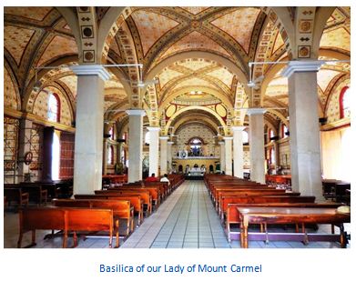 “high witch or sor- cerer”), which attracts up to 5,000 people. The event was founded in the 1970s by former brujo mayor Gonzalo Aguirre and today attracts around 200 shamans, healers (curanderos), herbalists, psychics and fortune tellers. It also brings in as much as three million pesos to the local economy.
The popularity of the brujos and the event has created problems as well. Many con artists have taken advantage of the situation, making the finding of genuine practitioners difficult. There have been disputes among the practitioners over clients, tourism and who leads the rites at the annual gathering. There has also been controversy related to those who sacrifice ani- mals or petition Santa Muerte or the Devil.
History
In the early pre Hispanic period, the area was dominated by the Olmecs, but the name is derived from Nahuatl, meaning “place of the burned houses.” This name is probably in reference to an eruption of the San Martin Volcano.
From the 16th century, the area was part of the province of Santiago Tuxtla, which became a municipality after Independence. The city itself was founded in 1774. In 1881, it officially became a town and in 1966 was declared a city.
Download the full edition or view it online
Dan and Lisa Goy, owners of Baja Amigos RV Caravan Tours, have been making Mexico their second home for more than 30 years and love to introduce Mexico to newcomers.