
By Terry Sovil from the May 2011 Edition
Everyone loves the local beaches, the water movement, the coming and going of ships and the sunsets over the point. So what’s the deal with Manzanillo’s ocean?
 Where do we “fit” in Mexico and what do we have locally to set us apart?
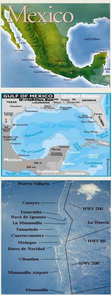
Mexico’s Beach Areas
Mexico is generally divided into three main “beach” areas, they are:
Gulf Coast – This is the Gulf of Mexico where we find the large state of Veracruz. There are not a lot of beautiful beaches here but a lot of oil wells.
Caribbean Coast – This coastal area is called the Maya Riviera and includes such locations as Puerto Morelos, Cancun, Playa del Carmen, Cozumel and Tulum. These are some of the biggest tourist spots in Mexico and enjoy the more temperate and clearer water than we do in Manzanillo.
Pacific Coast — Often called the “Gold Coast” it is divided into two parts: Baja California, adjoined by the North Pacific Ocean and the Sea of Cortez (Gulf of California) and the more southerly mainland. The Pacific Coast offers the greatest variety of beaches in Mexico and some of the most beautiful in the world. You may also hear the terms “Mexican Riviera” and “Costa Alegre”.
The Southern Coast runs from Acapulco to Salina Cruz. The Northern Coast runs from Mazatlan to Manzanillo. Costa Alegre (Cheerful Coast) is located from just below Puerto Vallarta to just above Cihuatlan and was created as an Ecological zone by a 1990 Presidential decree.
Temperatures
Temperatures vary with the season but are pretty consistent with air temperatures averaging 89 degrees F / 31 C for highs and 78 F / 25 C for lows. Water temperatures average 78-83 F / 25-28 C but thermoclines and upwelling can cause temperatures to go as low as 65 F / 18 C. Water visibility can average 50-80 feet / 16-27 m.
Water Movement
Water movement in our bays reflects whatever is happening on the open Pacific and includes tides, current, surge and weather created water movement.
Tides
Tides are created by gravitational interaction of the earth’s rotation with the moon and the sun. Tides can either be “diurnal” – one high tide and one low tide per day; “semidiurnal” – two high tides and two low tides per day or “mixed tides” – which is what Manzanillo has. Our tides vary between diurnal and semidiurnal.
Rebalses
This term refers to a strong wave action on the Pacific coast that affects all water sports. Rebalses
(when the sea “rebels”) are most strong in April, May and June. They seldom occur in November, December and January. There is a period of “high seas” lasting 2-3 days beginning about 3-4 days following a full moon. Also, a period of lesser severity may begin 2-3 days after a new moon.
The period of rebalses is usually short and swimming at beaches (cautiously) can be enjoyed most of the time.
Weather
Weather can also cause periods of high seas and big waves. We may see very big seas during hurricane season when one such passes by offshore. Often there is only rain on the mainland but the wind offshore can create huge seas that come moving into our mostly open bays. During these periods it may not be safe for swimming or boating.
The recent earthquake and tsunami which hit Japan recently, produced tsunami warnings here in Manzanillo. Schools closed for the day whilst aftershocks caused very unsettled seas for more than two weeks. On Monday March 28 the Mexican Navy issued a warning for a strong swell up 9’/3m and issued a small craft advisory.
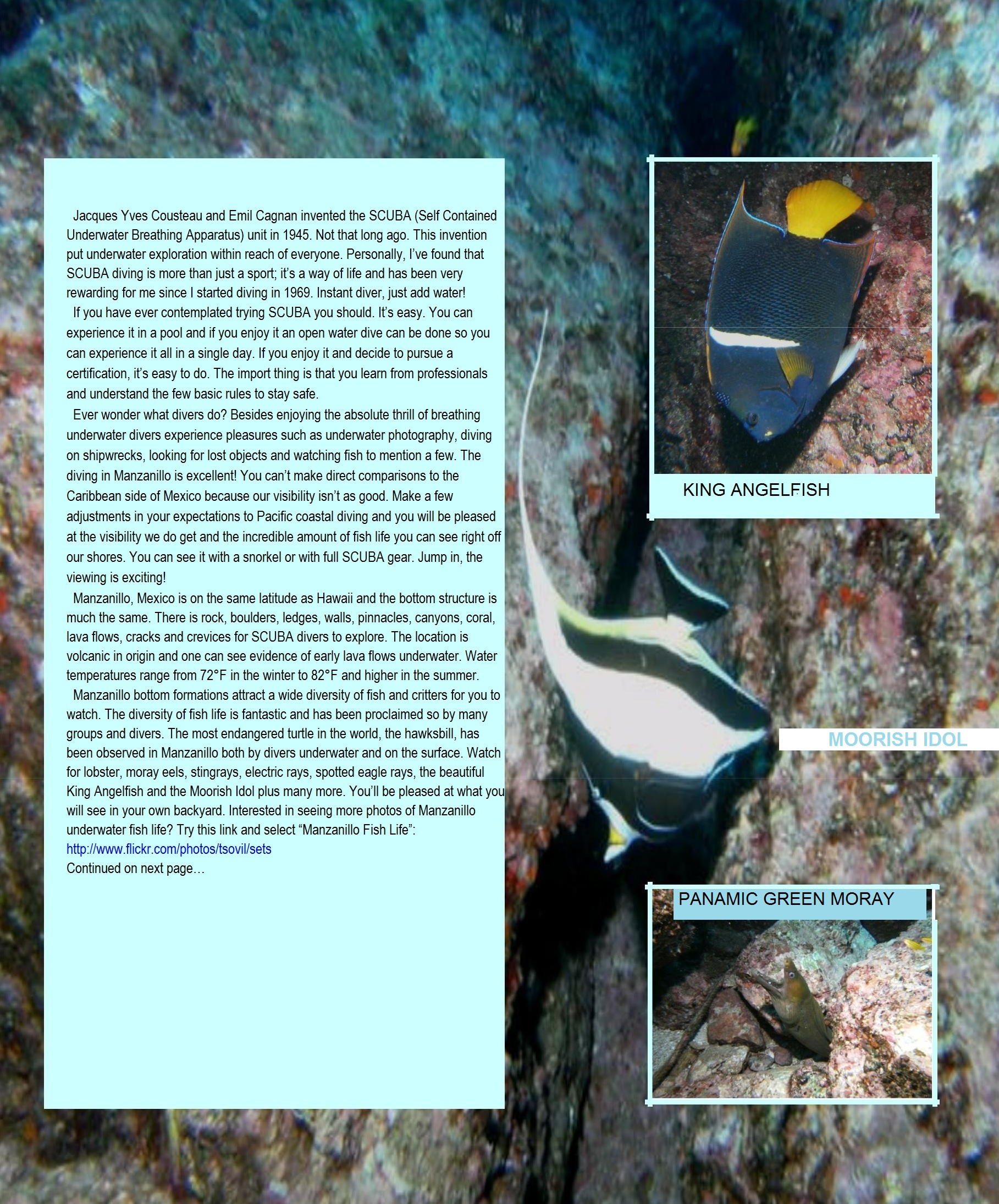
The constant churning of the seas prevents coral reefs from developing along our coast. While we have small colonies and one area with tremendous stands of coral we do not get the large fringing reefs but we do get small colonies of coral and reef fish are abundant.
Current and Surge
The movement of water against our beaches and shores can cause various types of currents. A surge is a fast and forceful movement of water forward or upward, followed by a less forceful flow back the other way. Currents can be created on some of our beaches when the wind and current driven waves hit the beach at angle and then flow parallel to the beach. This is a long shore current. We also have conditions where water piling up on the beach needs to return to the sea and a rip current is formed. If you have doubts watch for the flags in the beaches (red flags mark a rip current) and swim where the locals are swimming.
Next issue we will look at visibility and things that affect visibility for diving and snorkeling and some of the critters you may encounter that can cause you some pain.
Download the full edition or view it online
—
Terry is a founding partner and scuba instructor for Aquatic Sports and Adventures (Deportes y Aventuras Acuáticas) in Manzanillo. A PADI (Professional Association of Dive Instructors) Master Instructor in his 36th year as a PADI Professional. He also holds 15 Specialty Instructor Course ratings. Terry held a US Coast Guard 50-Ton Masters (Captain’s) License. In his past corporate life, he worked in computers from 1973 to 2005 from a computer operator to a project manager for companies including GE Capital Fleet Services and Target. From 2005 to 2008, he developed and oversaw delivery of training to Target’s Loss Prevention (Asset Protection) employees on the West Coast, USA. He led a network of 80+ instructors, evaluated training, performed needs assessments and gathered feedback on the delivery of training, conducted training in Crisis Leadership and Non-Violent Crisis Intervention to Target executives. Independently, he has taught hundreds of hours of skills-based training in American Red Cross CPR, First Aid, SCUBA and sailing and managed a staff of Project Managers at LogicBay in the production of multi-media training and web sites in a fast-paced environment of artists, instructional designers, writers and developers, creating a variety of interactive training and support products for Fortune 1000 companies.

You must be logged in to post a comment.