By Dan and Lisa Goy on the September 2019 Edition
Baja Highway: Mired in Myth-A Changing Reality
Mexican Federal Highway (Carretera Transpeninsular or Transpeninsular Highway) No. 1 follows the length of the Baja California Peninsula from Cabo San Lucas (BCS), at the southern end to Tijuana (BC) in the north.
Carretera Peninsular Benito Juárez is the highway’s official name and today it serves as Main Street for most of the settlements strung along its route. Most of its length is two lanes and construction was completed in 1973. It is also known simply as Highway 1, an appropriate number for the road that brought the modern world to Baja. The road turns into Interstate 5 at the international border with the United States south of San Ysidro, California and runs a length of 1,711 km (1,061 miles).
We first drove on Hwy 1 in November 1985. At the time, it did not seem that narrow, not surprising as we were driving a converted Ford Camper Van. Dan was 30, Lisa was 25 and the kids were 2 and 4 years old.
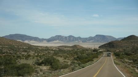
Even today, 95% of the highway is only two lanes wide, historically less than ten meters (19’ wide with 9.5’ lanes) in the least traveled middle of the route. The new highway was designed and built by modern engineers, so curves are broad and gentle, grades are moderate, and visibility is generally good.
Since water for construction was always scarce and sometimes had to be hauled scores of miles, an ingenious, water sparing, roadbed construction scheme was devised. The final surface was oiled and covered with fine gravel. Unfortunately, shoulders were few and far between. Except where the highway is actually cut into a hillside, it runs on top of an artificial ridge more than a meter high and only slightly wider than the road-bed. To build this ridge, earth was scraped from as much as a hundred yards on both sides, destroying the vegetation, much of it unusual endemic plants, and leaving a scar that will remain for decades if not for centuries. Protection against wash-outs, rather than maintaining the wildly beautiful desert environment, clearly had precedence in the engineers’ plans.
The heavy investment in the new highway was justified by its attraction of vastly increased numbers of American tourists and the employment that will be created in providing them with services. The American visitors, prior to the paving of the highway have been of two classes, the drivers who traveled slowly, enjoying the scenery and the nearly empty country, camping out and spending relatively little money; another group flew to luxury resort hotels, particularly for fishing.
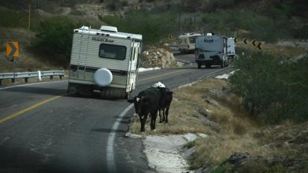
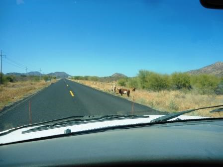
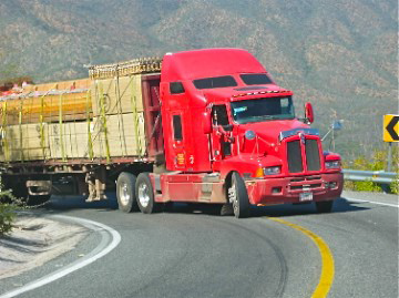
Unfortunately, Hwy 1 developed a well-deserved, notorious reputation over the years as a white-knuckle experience for RVers, particularly for those driving bigger rigs. The problem was a combination of the narrow roads, the lack of shoulders, no livestock fencing, unmarked speed bumps (topes), locals willing to chance fate at every corner and zero enforcement of basic road rules. Thankfully, much has changed, particularly the highway, although Rule #1 of Baja remains “Don’t Drive at Night”, this is certainly not about banditos. This is about hit-ting a cow, donkey or horse!
Kilometre markers track the distance along Mex 1 through Baja California Norte in four segments. The first of these is the 109 km length from Tijuana to Ensenada, which is known informally as Mex 1 Libre to distinguish it from the parallel toll road. The second portion of signed road runs 196 km from Ensenada to San Quintín. The third segment comprises 128 km from San Quintín to the Bahía de los Ángeles junction. A final segment stretches 128 km from Bahía de los Ángeles junction to the border of Baja California Sur. The total length of Mexican Federal Highway 1 in Baja California Norte is 713 km (436 mi).
After crossing state lines, the kilometre markers progress in the opposite direction. Baja California Norte markers count from north to south, but Baja California Sur markers count from south to north. So, in opposite order from the road sign-age, a progressive route southward would span 221 km from Guerrero Negro to Santa Rosalía, 197 km from Santa Rosalía to Loreto, 120 km from Loreto to Ciudad Insurgentes, 240 km from Ciudad Insurgentes to La Paz, and 224 km from La Paz to Cabo San Lucas.
You have had the option of a 4-lane, toll highway 1 for many years now from Tijuana to Ensenada and most of Highway 3 from Tecate to Ensenada through Baja wine country has been completely rebuilt, with lots of new 4-lane road, wide lane and equally wide, paved shoulders. The road construction over the last few years, from Ensenada to Cabo San Lucas, is nothing short of remarkable and extraordinary. Just this past season, a harrowing winding descent into the Santo Tomas Valley south of Ensenada was replaced as they literally cut directly through the mountain, a real engineering feat.
In the past, we used to keep a detailed report on where the new and improved highway replaced the old narrow road, now we just keep track of what old road remains. What we are finding is the worst pavement in one season seems to be replaced the very next season. Another significant factor is all the new bridges straddling the vados (dry creeks beds) that would commonly block the highway in those rare rain storms.
These are well constructed and very wide, a real pleasure to drive on, for sure.
Once you get to La Paz, the capital city of Baja Sur, you have two (2) options for your drive to Cabo San Lucas, Mex 1 down the east cape past Los Barriles and San Jose del Cabo or on Highway 19 through Todos Santos. Mex 1 is 4 lanes all the way to the turn off to the west and Todos Santos. After that, the road returns to 2 lanes.
The road is good, however, the first stretch where you drive past El Triunfo, San Antonio and San Bartolo is in the moun-tains with lots of switchback and blind corners. Take it slow and easy, listen for big rigs and busses coming from the other direction. Taking the Pacific route along Highway 19 through Todos Santos and Pescadero is a real treat, actually better than the I-5! With the exception of Todos Santos, you are on a divided, 4-lane highway for the entire drive. The section from Todos Santos south was just completed this year.
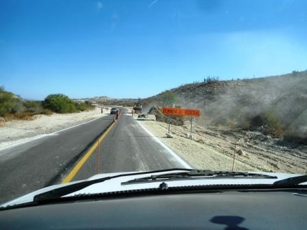
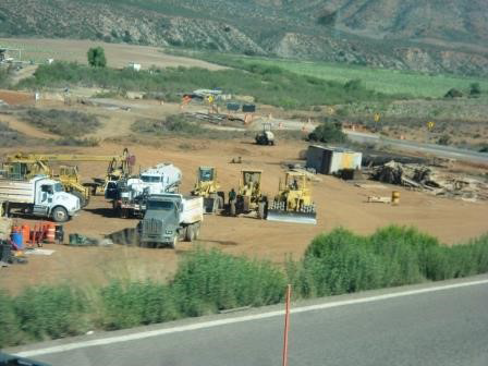
Road Construction Zones
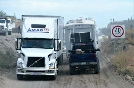
We always come across road construction and will continue to do so for the foreseeable future. At the end of the day, this is all good as the highway will be better and safer to drive on. However, there are a few things you should note when you are in a Baja road construction zone. We all have the experience of road construction in the US and Canada on major transportation routes. Usually you find lots of flaggers, all is well marked, plenty of cones are in evidence, speed signs abound and most everyone understands the need to slow down.
Unfortunately, this is not necessarily the case as we cross the Mexican border and head for Cabo San Lucas. Often locals, cars, busses and sometimes big rigs seize on the opportunity, with some folks going slow to pass and, since signage and markers are somewhat non-existent, flaggers are hard to find and there is zero enforcement by the police, these work zones can be mistaken for organized chaos. Our advice is simple go slow and leave lots of room for others to pass or get out of the way and enjoy the vehicular theatre.
Speed is the problem, not the road! Our experience on Baja demonstrates that the best advice we can provide RVers is to slow down, drive defensively, do not drive at night and you will be just fine. As we lead RV Caravans, we ensure we assist those wanting to pass (left turn signal when it is clear) and ensure there is always room for any passer to get back in the line. We have the benefit of radios to communicate to talk to each other.
If traveling with another couple, we recommend you purchase some they are relatively inexpensive. When facing oncoming traffic, particularly larger vehicles on the narrower stretches, slow down, move over and keep focused. Always keep your eyes open for large animals on the road Often, they blend in and are hard to see. If you come across an oncoming vehicle with their 4-way flashers on, take notice. Something ahead on the road needs your attention. We have lost a couple of mirrors over the years (we have the strap on kind) and, without exception, Mexicans are not to blame as 99% of the truck and bus drivers are great and always give you enough room.
Other RVers have knocked off all our mirrors, both passing us in the same direction and oncoming. Why? They were going fast, riding too close on the center line and, simply put, over-driving the road given their experience, size of rig and pavement conditions.
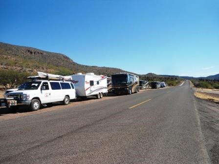
Baja is unforgiving for RVs that leave the highway, so you need to avoid this experience, remain between the lines and just enjoy this magnificent peninsula.
The full edition or view it online
Dan and Lisa Goy, owners of Baja Amigos RV Caravan Tours, have been making Mexico their second home for more than 30 years and love to introduce Mexico to newcomers.