By Terry Sovil from the July 2018 Edition
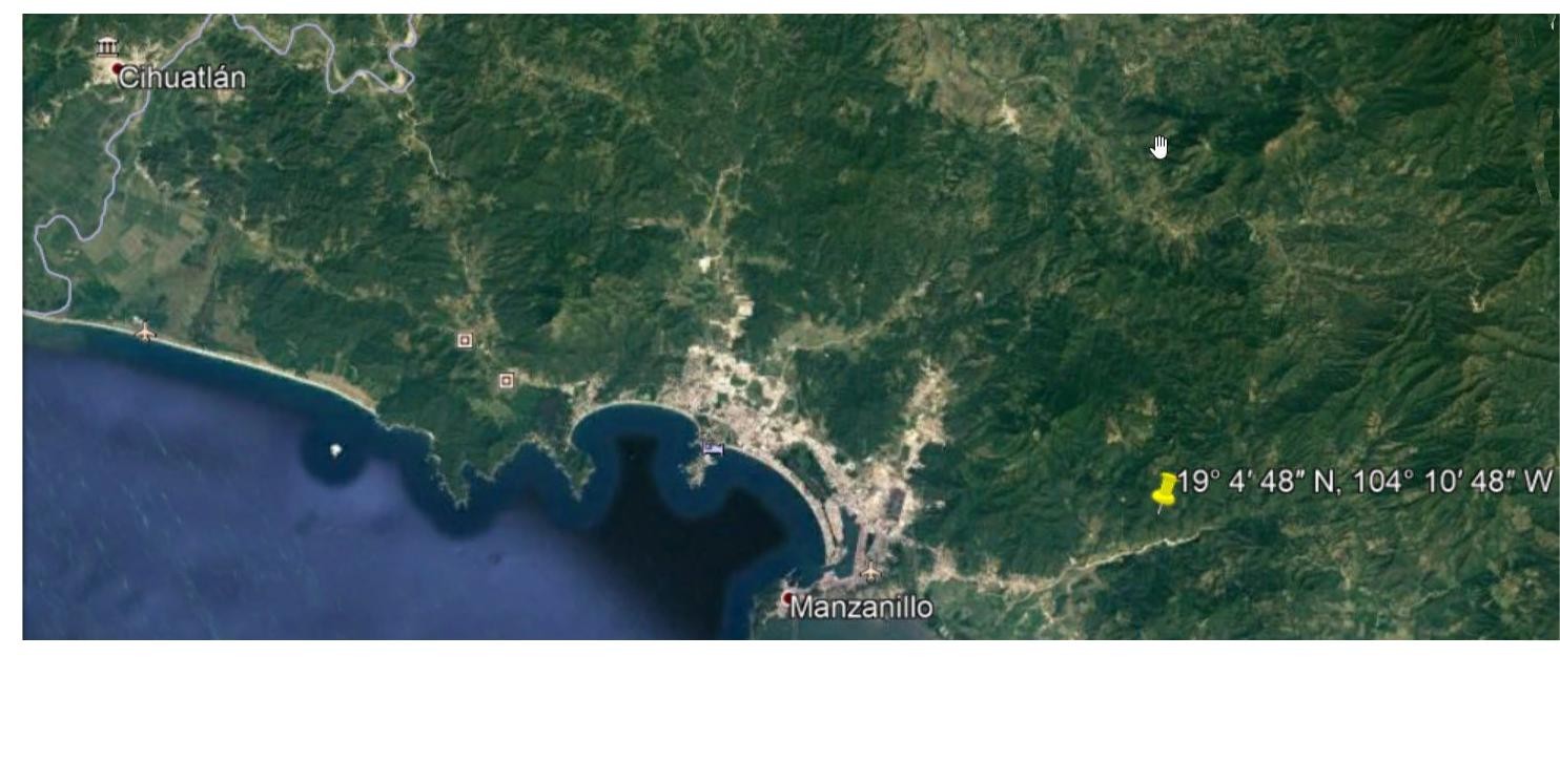
On Monday, October 9, 1995 at 9:38AM a huge earthquake struck Cihuatlán-Manzanillo. It was an 8 on the moment magnitude scale or 7.6 on the Richter scale. It was on shore, at a depth of 40km / 25 miles, with a Mercalli intensity of “severe” (7), lasting about a minute. It was felt in Mexico City and in some high rise buildings in Dallas and Houston, Texas. The earthquake is notable for directing damage northwestward from the epicenter, up the Pacific coastline, while sparing the epicentral region and the area down the coastline.
 The Mercalli intensity scale is a newer measurement from Italy for intensity of the quake. It is a scale of earth-quake intensity ranging from I for an earthquake detected only by seismographs to XII for one causing total destruction of all buildings. The moment magnitude scale is one of many seismic magnitude scales used to measure the size of earthquakes.
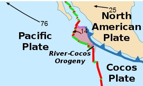
The scale was developed in the 1970s to succeed the 1930s-era Richter magnitude scale. It was a shallow interplate thrust earthquake. An interplate earthquake occurs at the boundary between two tectonic plates. Interplate earthquakes associated at a subduction boundary are called megathrust earthquakes, the most powerful earthquakes.
In Mexico City, it was reported that the 63 story glass and steel headquarters of Petroleos Mexicanos (Pemex), the state owned oil monopoly, swayed terrifyingly by a yard or more. At least 49 people died and 100 were injured in the city of Manzanillo and about 10 in the affected area of Jalisco. Initially, it was thought that as many as 57 died, but later the results were cut back.
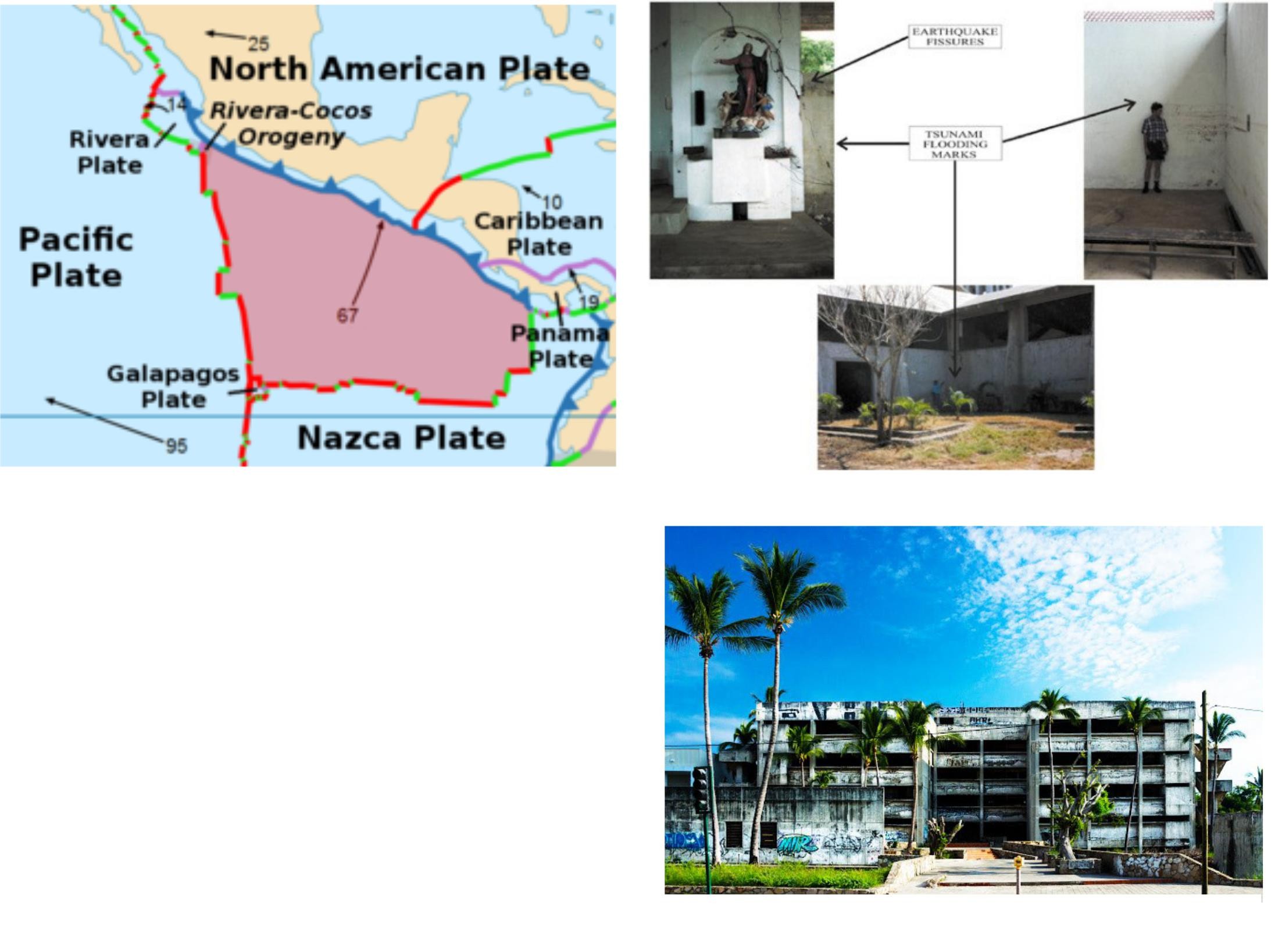
The earthquake was in the area of the Rivera Plate beneath the North American Plate, caused by movements between the North American Plate, the Rivera Plate and the Cocos Plate. Near the epicenter, about 17,000 structures were damaged or collapsed, affecting about 45,000 people. Most affected was the Cihuatlán area, with 90% of the buildings damaged and 20% of them destroyed. Manzanillo, the bigger city, saw only about 5% of the structures damaged but enough to significantly affect the local economy.
The aftershocks were in a rectangular region about 170 km x 70 km / 106 x 43 miles. The main shock area was about 24km south of Manzanillo and the aftershock area 20 km offshore of Manzanillo. The Jalisco State government reported that the ho-tel Costa Grande, a large tourist hotel in San Patricio Melaque,had also collapsed. They reported 11 people dead but later revised the report to hotel damage with no loss of life.
Eighteen people died in the collapse of an eight story hotel,the Costa Real, a beach-front hotel in Manzanillo. Some 50 people were inside and the navy and rescue crews searched with cranes. In newspaper reports, Michael Farley, an American who was on his yacht in the Manzanillo harbor, watched the Hotel Costa Real “crumble right before my eyes,” he said. He was interviewed over short wave radio and telephone.
Farley said “Everybody was yelling and pointing at the hotel. It looked like one of those films on TV, where the guys come in with dynamite and destroy the building. We watched it collapse into a pile of dust.”
Mr. Farley noted that water in the bay fell 10 feet / 3 meters during the quake and came screaming back in a huge wave.
In Jalisco, at least 10 people were killed and about 90 seriously injured according to a Mr. Naveja, the Jalisco spokesman. Nine of the deaths came in Cihuatlán and another person died in the nearby town of Mascota. Most were killed by collapsing homes. He estimate that some 900 homes collapsed.
Landslides blocked the highways between Melaque and Cihuatlán. Two bridges, spanning the Seco and Jualuco Rivers in Jalisco, collapsed, according to radio reports. Landslides blocked roads between Guadalajara and Manzanillo.
Probably one of the most visible earthquake examples is the old hospital that was declared unsafe and sits right next to the new Home Depot.The tsunami (tidal wave) affected a 200 km / 124 miles stretch of coast. Most damage was in shallow shoreline areas. Flooding was in the Tenacatita Bay area. The wave had a maximum wave height of 5.1 meters / 16 ½ feet. At least 2 waves were recorded and it was also observed in parts of Ecuador, French Polynesia, Samoan Islands, Australia and Hawaii. Local citizens described the waves that hit the coast. Their testimonies were col-lected and the extent of the run-up were documented. There was a field survey done by Ortiz in 1995 and some corrections were made to the data.
The highest tsunami run-up was observed in Tenacatita Bay in the towns of La Manzanilla and Boca de Iguanas. The photo shows the flooding marks both inside and outside of the Temple of La Manzanilla.
There are videos, below, of the damages and the rescue efforts.
Links:
20 años después (video, 2:53)
Manzanillo earthquake update (video, 4:04)
Download the full edition or view it online
—
Terry is a founding partner and scuba instructor for Aquatic Sports and Adventures (Deportes y Aventuras Acuáticas) in Manzanillo. A PADI (Professional Association of Dive Instructors) Master Instructor in his 36th year as a PADI Professional. He also holds 15 Specialty Instructor Course ratings. Terry held a US Coast Guard 50-Ton Masters (Captain’s) License. In his past corporate life, he worked in computers from 1973 to 2005 from a computer operator to a project manager for companies including GE Capital Fleet Services and Target. From 2005 to 2008, he developed and oversaw delivery of training to Target’s Loss Prevention (Asset Protection) employees on the West Coast, USA. He led a network of 80+ instructors, evaluated training, performed needs assessments and gathered feedback on the delivery of training, conducted training in Crisis Leadership and Non-Violent Crisis Intervention to Target executives. Independently, he has taught hundreds of hours of skills-based training in American Red Cross CPR, First Aid, SCUBA and sailing and managed a staff of Project Managers at LogicBay in the production of multi-media training and web sites in a fast-paced environment of artists, instructional designers, writers and developers, creating a variety of interactive training and support products for Fortune 1000 companies.